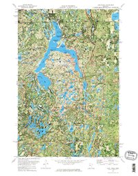
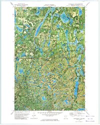
1972 Map of Lake Itasca
USGS Topo · Published 1974About this map
Lake Itasca, the storied source of the Mississippi River, is documented here at a time when its surrounding park infrastructure was well-established. This 1970s orthophotomap combines aerial imagery with topographic data to show the dense forest canopy of Itasca State Park, which encompasses numerous glacial lakes like Elk Lake and Mary Lake. The human footprint on this landscape is centered around the Univ of Minn Forestry Sch and historical sites such as the Pioneer Cem and the Museum. Key navigation points like Schoolcraft Island and Yellow Head Point are clearly visible within the lake's distinct arms. Further south, the landscape transitions into the Savannah Township boundary, dotted with smaller water bodies and fire suppression infrastructure, including the Alton Heights Lookout Tower and Little Mantrap Lookout Tower.
Find a feature on this map
90 named features on this map. Tap any name to fly to it.
Don’t see what you’re looking for? This feature index may not catch every label — zoom into the map to look around manually.
Map Details
Editions of this 1972 Lake Itasca Map
2 editions found
Other maps of this area

1954 · Bemidji
USGS Topo · 1:250,000

1957 · Bemidji
USGS Topo · 1:250,000

1958 · Bemidji
USGS Topo · 1:250,000

1969 · Anchor Hill
USGS Topo · 1:24,000

1969 · Big Basswood Lake
USGS Topo · 1:24,000

1969 · Heart Lake
USGS Topo · 1:24,000

1972 · La Salle Lake
USGS Topo · 1:24,000
1972 · Two Inlets
USGS Topo · 1:24,000
1972 · Lake Hattie
USGS Topo · 1:24,000
1972 · Schoolcraft Lake
USGS Topo · 1:24,000