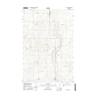
2016 Map of La Salle Lake
USGS Topo · Published 2016About this map
The Mississippi River meanders through the marshy lowlands of the Clearwater and Hubbard county line in this 2016 survey. This landscape is defined by its glacial hydrology, featuring a chain of significant water bodies including LaSalle Lake, Middle LaSalle Lake, and Big LaSalle Lake. The small settlement of Vern sits centrally, serving as a landmark in a region dominated by timber and wetlands. Local history is preserved at the Sell Lake Cem and Old Sell Lake Cem, which offer physical evidence of early homesteading patterns in the township. In the southern reaches of the map, the community of Lake Itasca marks the area's transition toward the headwaters region. The presence of the Mallard Grade Trl and various township roads like Itasca Twp Rd 141 indicates a network established for both recreation and resource access in the north woods.
Find a feature on this map
45 named features on this map. Tap any name to fly to it.
Don’t see what you’re looking for? This feature index may not catch every label — zoom into the map to look around manually.
Map Details
Editions of this 2016 La Salle Lake Map
This is the sole edition of this map. No revisions or reprints were ever made.
Other maps of this area

1954 · Bemidji
USGS Topo · 1:250,000

1957 · Bemidji
USGS Topo · 1:250,000

1958 · Bemidji
USGS Topo · 1:250,000

1969 · Anchor Hill
USGS Topo · 1:24,000

1969 · Heart Lake
USGS Topo · 1:24,000
1969 · Upper Rice Lake
USGS Topo · 1:24,000

1972 · Alida
USGS Topo · 1:24,000

1972 · La Salle Lake
USGS Topo · 1:24,000
1972 · Grant Lake
USGS Topo · 1:24,000
1972 · Lake Itasca
USGS Topo · 1:24,000