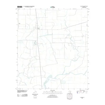
2010 Map of La Ward
USGS Topo · Published 2010About this map
La Ward stands at the center of this coastal prairie landscape, where the agricultural grid of Jackson County meets the meandering waterways of the Texas Gulf Coast. The town's layout is defined by the intersection of state and local routes, including FM 616 and Revel Rd, serving a region deeply tied to ranching and aviation, as seen at Whites Airport. The terrain is shaped by the complex drainage systems of West Carancahua Creek and East Carancahua Creek, which flow southward toward the headwaters of Carancahua Bay. This 2010 survey illustrates the persistence of family-named landmarks and rural infrastructure, from W Ward Ranch Rd to the various farm-to-market roads that connect scattered homesteads across the low-lying coastal plains. The map provides a clear look at the hydraulic patterns and property boundaries that define this portion of the Texas coast.
Find a feature on this map
17 named features on this map. Tap any name to fly to it.
Don’t see what you’re looking for? This feature index may not catch every label — zoom into the map to look around manually.
Map Details
Editions of this 2010 La Ward Map
This is the sole edition of this map. No revisions or reprints were ever made.
Other maps of this area

1952 · Francitas NW
USGS Topo · 1:24,000

1952 · Manson
USGS Topo · 1:24,000

1952 · Point Comfort
USGS Topo · 1:24,000

1952 · Olivia
USGS Topo · 1:24,000

1952 · Turtle Bay
USGS Topo · 1:24,000

1952 · Francitas
USGS Topo · 1:24,000

1952 · Francitas NE
USGS Topo · 1:24,000

1952 · La Ward
USGS Topo · 1:24,000

1952 · Lolita
USGS Topo · 1:24,000

1953 · Beeville
USGS Topo · 1:250,000