
1952 Map of Olivia
USGS Topo · Published 1953About this map
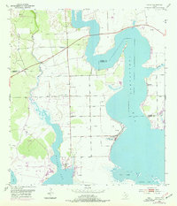
Keller Bay and Carancahua Bay dominate this coastal landscape, where the tides meet the flat Texas coastal plain. The settlement of Olivia serves as a focal point for the community, anchored by the Olivia Eden Ch and the local Olivia Sch. The geography reveals a reliance on water access and management, with a prominent Spoil Bank and several segments of Levee protecting the low-lying terrain near Port Alto.
Find a feature on this map
18 named features on this map. Tap any name to fly to it.
Don’t see what you’re looking for? This feature index may not catch every label — zoom into the map to look around manually.
Map Details
Editions of this 1952 Olivia Map
2 editions found
Other maps of this area

1951 · Keller Bay
USGS Topo · 1:24,000

1952 · Port Lavaca East
USGS Topo · 1:24,000

1952 · Point Comfort
USGS Topo · 1:24,000

1952 · Turtle Bay
USGS Topo · 1:24,000

1952 · Francitas
USGS Topo · 1:24,000

1952 · La Ward
USGS Topo · 1:24,000

1952 · Lolita
USGS Topo · 1:24,000

1953 · Beeville
USGS Topo · 1:250,000

1956 · Beeville
USGS Topo · 1:250,000

1960 · Beeville
USGS Topo · 1:250,000