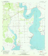
1952 Map of Olivia
USGS Topo · Published 1976About this map
The coastal interface of Carancahua Bay and Keller Bay defines this mid-century survey of the Texas Gulf Coast. This area along the boundary of Jackson and Calhoun counties shows a landscape defined by saltwater systems, including Salt Lake, Redfish Lake, and Cox Bay. The settlement pattern is concentrated in small coastal communities like Olivia, where local social life is anchored by the Olivia Eden Ch and the Olivia Sch.
Find a feature on this map
17 named features on this map. Tap any name to fly to it.
Don’t see what you’re looking for? This feature index may not catch every label — zoom into the map to look around manually.
Map Details
Editions of this 1952 Olivia Map
2 editions found
Other maps of this area

1951 · Keller Bay
USGS Topo · 1:24,000

1952 · Port Lavaca East
USGS Topo · 1:24,000

1952 · Point Comfort
USGS Topo · 1:24,000

1952 · Olivia
USGS Topo · 1:24,000

1952 · Turtle Bay
USGS Topo · 1:24,000

1952 · Francitas
USGS Topo · 1:24,000

1952 · La Ward
USGS Topo · 1:24,000

1952 · Lolita
USGS Topo · 1:24,000

1953 · Beeville
USGS Topo · 1:250,000

1956 · Beeville
USGS Topo · 1:250,000