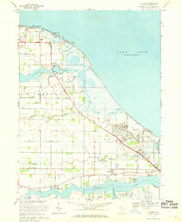
1967 Map of Lacarne
USGS Topo · Published 1969About this map
Camp Perry dominates the shoreline of Lake Erie in this late-1960s survey, showing its extensive military layout including a Heliport and Landing Strip. The map illustrates a landscape shaped by water and transport, where the Penn Central railroad cuts through the southern townships of Salem and Erie. This coastal region is marked by significant conservation areas like the Ottawa National Wildlife Refuge and the Little Portage River Wildlife Area, protecting the marshy terrain near the Toussaint River. Local infrastructure is well-defined, featuring the County Fairgrounds and County Home near the Portage River. Genealogists will find value in the clearly marked rural burial grounds, including Locust Point Cem and Rusha Cem, alongside small settlements such as Lacarne and Locust Point.
Find a feature on this map
35 named features on this map. Tap any name to fly to it.
Don’t see what you’re looking for? This feature index may not catch every label — zoom into the map to look around manually.
Map Details
Editions of this 1967 Lacarne Map
2 editions found
Other maps of this area

1900 · Oak Harbor
USGS Topo · 1:62,500

1901 · Put-In-Bay
USGS Topo · 1:62,500

1901 · Bellevue
USGS Topo · 1:62,500

1901 · Fremont
USGS Topo · 1:62,500

1903 · Bellevue
USGS Topo · 1:62,500

1903 · Fremont
USGS Topo · 1:62,500

1903 · Put In Bay
USGS Topo · 1:62,500

1952 · Oak Harbor
USGS Topo · 1:24,000

1952 · Lacarne
USGS Topo · 1:24,000

1952 · Oak Harbor
USGS Topo · 1:62,500