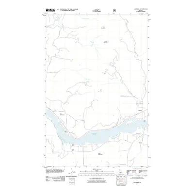
2011 Map of Laclede
USGS Topo · Published 2011About this map
Lake Pend Oreille serves as the central geographic feature of this Bonner County landscape, where the water dictates the placement of transit and habitation. The north bank is home to Laclede, a community positioned along the primary roadway near the Laclede Boat Ramp. To the west, small clusters of development include Thama and an area simply identified as The Settlement, suggesting a history of localized land divisions. On the opposite side of the water, the terrain becomes more industrial and commemorative, featuring the Carey Pits and the Seneacquoteen Cemetery near Sawyer.
Find a feature on this map
38 named features on this map. Tap any name to fly to it.
Don’t see what you’re looking for? This feature index may not catch every label — zoom into the map to look around manually.
Map Details
Editions of this 2011 Laclede Map
This is the sole edition of this map. No revisions or reprints were ever made.
Other maps of this area

1901 · Sandpoint
USGS Topo · 1:125,000

1911 · Priest Lake
USGS Topo · 1:250,000

1911 · Sandpoint
USGS Topo · 1:125,000

1913 · Priest Lake
USGS Topo · 1:250,000

1958 · Sandpoint
USGS Topo · 1:250,000

1963 · Sandpoint
USGS Topo · 1:250,000

1967 · Quartz Mtn
USGS Topo · 1:24,000

1967 · Prater Mtn
USGS Topo · 1:24,000
1968 · Blanchard
USGS Topo · 1:24,000
1968 · Happy Fork Gap
USGS Topo · 1:24,000