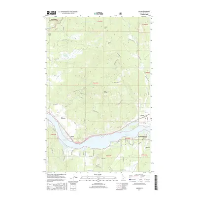
2017 Map of Laclede
USGS Topo · Published 2017About this map
Lake Pend Oreille serves as a dominant focal point for this Idaho landscape, where the northern waters meet the Priest River and the rural communities of Laclede and Thama. The map details the historical significance of river crossings, evidenced by Ferry Rd and Old Thama Ferry Rd, which connect the scattered homesteads and small settlements south of the water. To the north, the terrain rises sharply toward Lindsey Mtn and Grouse Mtn within the Kaniksu National Forest, dissected by drainages like Riley Cr and Sanborn Cr. Local history is anchored by sites like The Settlement and the Seneacquoteen Cem, situated near the early riverside community of Seneacquoteen. The presence of the Flying H Ranch Airport and various named logging and ranching roads throughout the timbered hills reflects the area's modern land use patterns alongside its pioneer foundations.
Find a feature on this map
118 named features on this map. Tap any name to fly to it.
Don’t see what you’re looking for? This feature index may not catch every label — zoom into the map to look around manually.
Map Details
Editions of this 2017 Laclede Map
This is the sole edition of this map. No revisions or reprints were ever made.
Other maps of this area

1901 · Sandpoint
USGS Topo · 1:125,000

1911 · Priest Lake
USGS Topo · 1:250,000

1911 · Sandpoint
USGS Topo · 1:125,000

1913 · Priest Lake
USGS Topo · 1:250,000

1958 · Sandpoint
USGS Topo · 1:250,000

1963 · Sandpoint
USGS Topo · 1:250,000

1967 · Quartz Mtn
USGS Topo · 1:24,000

1967 · Prater Mtn
USGS Topo · 1:24,000
1968 · Blanchard
USGS Topo · 1:24,000
1968 · Happy Fork Gap
USGS Topo · 1:24,000