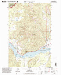
1996 Map of Laclede
USGS Topo · Published 1999About this map
The Pend Oreille River dominates this northern Idaho landscape, serving as a vital corridor for both timber industry and recreation. Along its northern banks, the settlement of Laclede appears as a focal point of activity, marked by a Sawmill and several boat launches including the Laclede Boat Ramp. To the west, the community of Thama sits near the river's edge, while Sawyer is situated further downstream. This 1996 revision by the USDA Forest Service highlights the managed character of the land, including the Hoodoo Game Management Area and the Priest River Game Management Area. Higher elevations are defined by the peaks of the Kaniksu National Forest, such as Gold Cup Mountain and Grouse Mountain. Historical roots are visible at the Seneacquoteen Cemetery, located near the southern shore where the Hoodoo Valley begins to open up.
Find a feature on this map
27 named features on this map. Tap any name to fly to it.
Don’t see what you’re looking for? This feature index may not catch every label — zoom into the map to look around manually.
Map Details
Editions of this 1996 Laclede Map
This is the sole edition of this map. No revisions or reprints were ever made.
Other maps of this area

1901 · Sandpoint
USGS Topo · 1:125,000

1911 · Priest Lake
USGS Topo · 1:250,000

1911 · Sandpoint
USGS Topo · 1:125,000

1913 · Priest Lake
USGS Topo · 1:250,000

1958 · Sandpoint
USGS Topo · 1:250,000

1963 · Sandpoint
USGS Topo · 1:250,000

1967 · Quartz Mtn
USGS Topo · 1:24,000

1967 · Prater Mtn
USGS Topo · 1:24,000
1968 · Blanchard
USGS Topo · 1:24,000
1968 · Happy Fork Gap
USGS Topo · 1:24,000