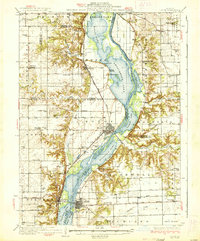
1937 Map of Lacon
USGS Topo · Published 1937About this map
The Illinois River valley dominates this landscape, carving a wide path through the central plains and creating an intricate network of backwater lakes and sloughs. Settled during the mid-1930s, the river corridor features large bodies of water such as Senachwine Lake, Swan Lake, and Billsbach Lake, which are flanked by the Chicago Rock Island and Pacific railroad to the west. This transport artery serves riverfront settlements like Putnam, Henry, and Sparland, illustrating a landscape deeply tied to the commercial and natural rhythms of the river.
Find a feature on this map
86 named features on this map. Tap any name to fly to it.
Don’t see what you’re looking for? This feature index may not catch every label — zoom into the map to look around manually.
Map Details
Editions of this 1937 Lacon Map
2 editions found

Other maps of this area

1893 · Lacon
USGS Topo · 1:62,500

1893 · Hennepin
USGS Topo · 1:62,500

1893 · Metamora
USGS Topo · 1:62,500

1893 · Dunlap
USGS Topo · 1:62,500

1893 · Lasalle
USGS Topo · 1:62,500

1898 · Dunlap
USGS Topo · 1:62,500

1909 · Hennepin
USGS Topo · 1:62,500

1911 · La Salle
USGS Topo · 1:62,500

1911 · Hennepin
USGS Topo · 1:62,500

1913 · La Salle
USGS Topo · 1:62,500