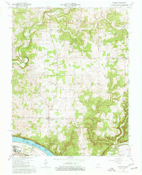
1966 Map of Laconia
USGS Topo · Published 1968About this map
Laconia serves as the focal point of this Harrison County landscape, situated amidst a network of rural townships including Webster, Posey, and Boone. The mid-1960s terrain is marked by a deep commitment to community and ancestry, evidenced by numerous local landmarks like St Michaels Church, Rehoboth Church, and the South Central School. To the south, the Ohio River forms a definitive border with Kentucky, where the river economy is represented by Tobacco Landing and a nearby Landing Strip. The physical geography is defined by significant karst and drainage features, from the subterranean Big Spring Cave to the prominent Hogback Ridge. Smaller hamlets like Dogwood and Mays are connected by winding roads that pass by several historic burial grounds, including Old Goshen Cemetery and Dunkard Cemetery, offering a detailed view of the region's social geography before late-century modernization.
Find a feature on this map
39 named features on this map. Tap any name to fly to it.
Don’t see what you’re looking for? This feature index may not catch every label — zoom into the map to look around manually.
Map Details
Editions of this 1966 Laconia Map
3 editions found
Other maps of this area

1909 · Kosmosdale
USGS Topo · 1:48,000

1912 · Kosmosdale
USGS Topo · 1:62,500

1931 · Corydon
USGS Topo · 1:62,500

1936 · Vine Grove
USGS Topo · 1:62,500

1941 · Ekron
USGS Topo · 1:62,500

1943 · Vine Grove
USGS Topo · 1:62,500

1944 · Corydon West
USGS Topo · 1:24,000

1946 · Rock Haven
USGS Topo · 1:24,000

1946 · Fort Knox
USGS Topo · 1:24,000

1946 · Vine Grove
USGS Topo · 1:62,500