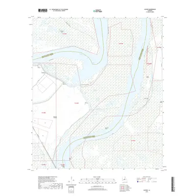
2018 Map of Lacour
USGS Topo · Published 2018About this map
The shifting course of the Mississippi River dominates this portion of the Louisiana landscape, where the border between Pointe Coupee Parish and West Feliciana Parish weaves through a complex system of oxbow lakes and islands. The remnant Raccourci Old River and Monday Lake trace the old riverbed, leaving behind significant landmasses like Raccourci Island and Tunica Island. On the western bank, the settlement of Lacour sits near the massive Morganza Floodway, an essential piece of regional water management infrastructure. Local history is anchored by several rural burial sites, including Mount Zion Cem, Mount Olive Cem, and Little Rock Cem, which serve as permanent markers of the community despite the persistent changes brought by the river's movement. Further south, the river forms Morgans Bend and passes Iowa Point, illustrating the high-energy hydrology that continues to shape the parishes.
Find a feature on this map
38 named features on this map. Tap any name to fly to it.
Don’t see what you’re looking for? This feature index may not catch every label — zoom into the map to look around manually.
Map Details
Editions of this 2018 Lacour Map
This is the sole edition of this map. No revisions or reprints were ever made.
Other maps of this area

1906 · Bayou Sara
USGS Topo · 1:125,000

1939 · St. Francisville
USGS Topo · 1:62,500

1939 · Fordoche
USGS Topo · 1:62,500

1941 · Batchelor
USGS Topo · 1:62,500

1953 · New Roads
USGS Topo · 1:24,000

1954 · Baton Rouge
USGS Topo · 1:250,000

1955 · Fordoche
USGS Topo · 1:62,500

1955 · Batchelor
USGS Topo · 1:62,500

1956 · Baton Rouge
USGS Topo · 1:250,000

1959 · Fordoche
USGS Topo · 1:62,500