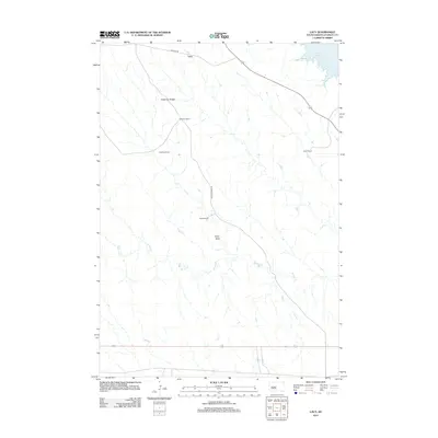
2012 Map of Lacy
USGS Topo · Published 2012About this map
Anderson Ridge dominates the high ground in this section of Stanley County, where the rangeland is defined by a network of drainage systems feeding toward the Missouri River basin. The settlement of Lacy sits at the northern edge of the quadrangle along Sansarc Rd, serving as a focal point for a landscape characterized by large ranching operations. Tracing the watershed revealed here, one can see how Willow Cr and Ash Cr carve through the terrain, with Casey Draw providing a distinct geographic marker between working lands. The northeastern corner of the map captures the irregular shoreline of Lake Oahe, illustrating how the massive reservoir reaches into the draws of the South Dakota prairie. Several family-named homesteads, including Anderson Ranch, Madison Ranch, Monks Ranch, and Lewis Ranch, are linked by a sparse network of roads like Willow Creek Rd, reflecting the enduring cattle-ranching heritage of the region.
Find a feature on this map
12 named features on this map. Tap any name to fly to it.
Don’t see what you’re looking for? This feature index may not catch every label — zoom into the map to look around manually.
Map Details
Editions of this 2012 Lacy Map
This is the sole edition of this map. No revisions or reprints were ever made.
Other maps of this area

1937 · Oahe
USGS Topo · 1:62,500

1953 · Teton
USGS Topo · 1:24,000

1953 · Oahe SW
USGS Topo · 1:24,000

1954 · Pierre
USGS Topo · 1:250,000

1958 · Pierre
USGS Topo · 1:250,000
1973 · Iron Post Buttes SE
USGS Topo · 1:24,000

1973 · Iron Post Buttes SW
USGS Topo · 1:24,000
1973 · Willow Creek Butte
USGS Topo · 1:24,000

1980 · Princes Ranch
USGS Topo · 1:25,000
1982 · Doty Ridge
USGS Topo · 1:24,000