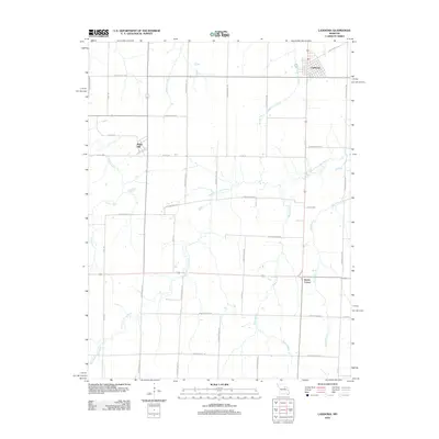
2012 Map of Laddonia
USGS Topo · Published 2012About this map
Laddonia serves as the primary municipal hub in this portion of Audrain County, situated along a grid of agricultural section lines and rural routes. The landscape is defined by the winding course of the West Fork Cuivre River, which meanders across the southern half of the quadrangle, joined by several significant tributaries. To the west, the village of Rush Hill marks a secondary point of settlement, while Scotts Corner occupies a rural crossroads to the southeast. The drainage pattern of the region is exceptionally detailed, featuring Middle Lick Creek and West Lick Creek in the north, alongside numerous named waterways like Littleby Creek and Johns Branch. This network of sloughs and branches, including the notably named Mams Slough, illustrates the natural irrigation that has long supported the area's farming character.
Find a feature on this map
40 named features on this map. Tap any name to fly to it.
Don’t see what you’re looking for? This feature index may not catch every label — zoom into the map to look around manually.
Map Details
Editions of this 2012 Laddonia Map
This is the sole edition of this map. No revisions or reprints were ever made.
Other maps of this area

1890 · Mexico
USGS Topo · 1:125,000

1932 · Mexico
USGS Topo · 1:62,500

1942 · Wellsville
USGS Topo · 1:62,500

1945 · Florida
USGS Topo · 1:62,500

1945 · Perry
USGS Topo · 1:62,500

1948 · Quincy
USGS Topo · 1:250,000

1956 · Quincy
USGS Topo · 1:250,000
1972 · Mexico East
USGS Topo · 1:24,000
1972 · Santa Fe
USGS Topo · 1:24,000
1972 · Mexico SE
USGS Topo · 1:24,000