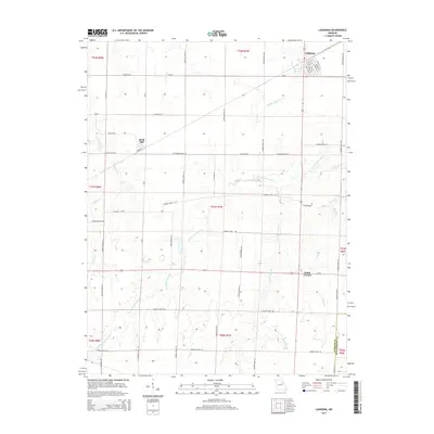
2015 Map of Laddonia
USGS Topo · Published 2015About this map
Laddonia serves as the primary hub on this Audrain County landscape, showing its organized street grid including Chestnut St, Walnut St, and Poplar St. The surrounding countryside is defined by the headwaters and tributaries of several drainage systems, most notably the meandering W Fork Cuivre River and the wetlands around Mams Slough. These watercourses carve through a predominantly agricultural terrain marked by a dense network of county roads. Smaller settlements like Rush Hill and Scotts Corner dot the landscape, connected by routes such as Audrain Road 424 and Audrain Road 708. The map also captures the Audrain Co Montgomery Co boundary at the southeastern corner. This survey documents the persistent rural character and precise land divisions of the Missouri prairie in the early twenty-first century.
Find a feature on this map
54 named features on this map. Tap any name to fly to it.
Don’t see what you’re looking for? This feature index may not catch every label — zoom into the map to look around manually.
Map Details
Editions of this 2015 Laddonia Map
This is the sole edition of this map. No revisions or reprints were ever made.
Other maps of this area

1890 · Mexico
USGS Topo · 1:125,000

1932 · Mexico
USGS Topo · 1:62,500

1942 · Wellsville
USGS Topo · 1:62,500

1945 · Florida
USGS Topo · 1:62,500

1945 · Perry
USGS Topo · 1:62,500

1948 · Quincy
USGS Topo · 1:250,000

1956 · Quincy
USGS Topo · 1:250,000
1972 · Mexico East
USGS Topo · 1:24,000
1972 · Santa Fe
USGS Topo · 1:24,000
1972 · Mexico SE
USGS Topo · 1:24,000