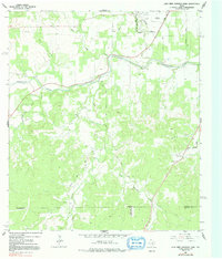
1964 Map of Lady Bird Johnson Park
USGS Topo · Published 1991About this map
Pedernales River frontage and the sprawling grounds of Lady Bird Johnson Park define this portion of the Texas Hill Country in the mid-1960s. The landscape is a network of family-named roads and remote community landmarks, including the Wrede Community House and the small settlement of Ransleben. Beyond the town boundaries, the terrain transitions into a series of creek valleys, such as Nasse Creek and Meusebach Creek, where the land was utilized for small-scale quarrying and ranching.
Find a feature on this map
33 named features on this map. Tap any name to fly to it.
Don’t see what you’re looking for? This feature index may not catch every label — zoom into the map to look around manually.
Map Details
Editions of this 1964 Lady Bird Johnson Park Map
3 editions found
Other maps of this area

1894 · Fredericksburg
USGS Topo · 1:125,000

1894 · Kerrville
USGS Topo · 1:125,000

1954 · Llano
USGS Topo · 1:250,000

1955 · Llano
USGS Topo · 1:250,000

1956 · Llano
USGS Topo · 1:250,000

1963 · Cain City
USGS Topo · 1:24,000

1964 · Oak Crest Park
USGS Topo · 1:24,000

1964 · Morris Ranch
USGS Topo · 1:24,000
1964 · Rafter Hollow
USGS Topo · 1:24,000
1964 · Cypress Creek
USGS Topo · 1:24,000