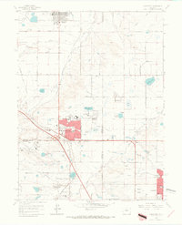
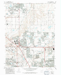
1965 Map of Lafayette
USGS Topo · Published 1967About this map
Lafayette and the rapidly developing communities along the Boulder Turnpike define this mid-1960s landscape at the foot of the Colorado Front Range. The expansion of Broomfield is clearly visible in the red-tinted residential blocks, contrasting with the legacy of the local coal mining industry represented by several Mine Dumps and a Gravel Pit. Transportation networks are a primary feature, with the Burlington and Quincy and Colorado and Southern railroads intersecting the grid of country roads and newer highways. Water management for the semi-arid plains is evident through an extensive system of canals and reservoirs, including the Highline Canal, Mc Kay Lake, and Nissen Reservoir No 2. Local landmarks like the Drive-in Theater near South Boulder Road and the County Airport underscore the mid-century shift toward suburban and commercial growth before the full urbanization of the Denver-Boulder corridor.
Find a feature on this map
62 named features on this map. Tap any name to fly to it.
Don’t see what you’re looking for? This feature index may not catch every label — zoom into the map to look around manually.
Map Details
Editions of this 1965 Lafayette Map
5 editions found
Other maps of this area

1890 · East Denver
USGS Topo · 1:125,000

1899 · West Denver
USGS Topo · 1:125,000

1902 · Greeley
USGS Topo · 1:125,000

1904 · Niwot
USGS Topo · 1:62,500

1938 · Derby
USGS Topo · 1:24,000

1939 · Golden
USGS Topo · 1:24,000

1940 · Eastlake
USGS Topo · 1:31,680

1940 · Lafayette
USGS Topo · 1:31,680

1940 · Derby
USGS Topo · 1:31,680

1941 · Arvada
USGS Topo · 1:31,680