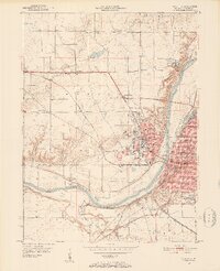
1950 Map of Lafayette
USGS Topo · Published 1952About this map
The Wabash River serves as the central artery for this mid-century survey of Tippecanoe County, where the growing urban footprints of Lafayette and West Lafayette meet the agricultural landscape. The expansive campus of Purdue University dominates the west bank, including the nearby Purdue Airport and Stadium. Notable cultural and historical landmarks are scattered throughout the river valley, from the Wabash Sanitarium in Cedar Hollow to the Ouiatenon Blockhouse on the southern river bend. The region's transport reliance is evident in the dense network of rail lines including the Wabash, New York Central, and Louisville and Nashville railroads. Beyond the city centers, rural life is marked by neighborhood gathering points like Sharon Chapel, Weaver Chapel, and Mt Zion Ch, providing clear points of reference for local genealogy and history.
Find a feature on this map
77 named features on this map. Tap any name to fly to it.
Don’t see what you’re looking for? This feature index may not catch every label — zoom into the map to look around manually.
Map Details
Editions of this 1950 Lafayette Map
2 editions found
Other maps of this area

1941 · Lafayette
USGS Topo · 1:24,000

1942 · Otterbein
USGS Topo · 1:24,000

1942 · Lafayette
USGS Topo · 1:24,000

1950 · Lafayette
USGS Topo · 1:24,000

1951 · Otterbein
USGS Topo · 1:24,000

1953 · Danville
USGS Topo · 1:250,000

1955 · Danville
USGS Topo · 1:250,000

1956 · Danville
USGS Topo · 1:250,000

1961 · Romney
USGS Topo · 1:24,000

1961 · Stockwell
USGS Topo · 1:24,000