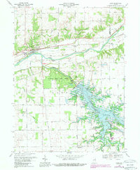
1969 Map of Lagro
USGS Topo · Published 1988About this map
The Wabash River and Salamonie River converge in this portion of Indiana, showing a landscape defined by the creation of Salamonie Lake. The 1969 survey, revised in the 1980s, documents the transition of the valley following the construction of the Salamonie Dam, which significantly altered the local hydrology and displaced earlier road networks. In the north, the town of Lagro remains a focal point along the Norfolk and Western railroad, while several rural spiritual and burial sites like St Patricks Cem and Hopewell Ch persist in the surrounding uplands.
Find a feature on this map
46 named features on this map. Tap any name to fly to it.
Don’t see what you’re looking for? This feature index may not catch every label — zoom into the map to look around manually.
Map Details
Editions of this 1969 Lagro Map
3 editions found
Other maps of this area

1950 · Lagro
USGS Topo · 1:24,000

1950 · Andrews
USGS Topo · 1:24,000

1950 · Mount Etna
USGS Topo · 1:24,000

1951 · Mount Etna
USGS Topo · 1:24,000

1951 · Andrews
USGS Topo · 1:24,000

1951 · Lagro
USGS Topo · 1:24,000

1952 · Wabash
USGS Topo · 1:24,000

1953 · La Fontaine
USGS Topo · 1:24,000

1953 · Somerset
USGS Topo · 1:24,000

1953 · Muncie
USGS Topo · 1:250,000