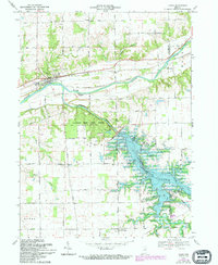
1969 Map of Lagro
USGS Topo · Published 1994About this map
The confluence of the Wabash River and the Salamonie River defines this landscape in Wabash County, where the 1969 field-check records a transition in land use. The northern section is anchored by Lagro, where the Wabash Railroad runs parallel to the waterway and St Patricks Cem sits near the town limits. To the south, the creation of Salamonie Lake has fundamentally altered the terrain, creating a sprawling reservoir that surrounds the Dora area and the Dora Christian Ch.
Find a feature on this map
40 named features on this map. Tap any name to fly to it.
Don’t see what you’re looking for? This feature index may not catch every label — zoom into the map to look around manually.
Map Details
Editions of this 1969 Lagro Map
3 editions found
Other maps of this area

1950 · Lagro
USGS Topo · 1:24,000

1950 · Andrews
USGS Topo · 1:24,000

1950 · Mount Etna
USGS Topo · 1:24,000

1951 · Mount Etna
USGS Topo · 1:24,000

1951 · Andrews
USGS Topo · 1:24,000

1951 · Lagro
USGS Topo · 1:24,000

1952 · Wabash
USGS Topo · 1:24,000

1953 · La Fontaine
USGS Topo · 1:24,000

1953 · Somerset
USGS Topo · 1:24,000

1953 · Muncie
USGS Topo · 1:250,000