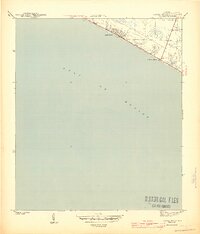
1943 Map of Laguna Beach
USGS Topo · Published 1943About this map
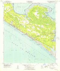
Laguna Beach and the neighboring settlement of Gulf Resort Beach line the narrow strip of land between the coastal marshes and the Gulf of Mexico in this 1943 survey. Prepared during the height of the war by the War Department and the Geological Survey, the map captures the early footprint of these coastal communities before the massive postwar development of the Florida Panhandle. The topography is dominated by low-lying wetlands and sandy shorelines, with the primary road network closely hugging the coast to connect these fledgling beach resorts. This wartime edition provides a clear record of the area's transition from a sparse coastal landscape into a series of interconnected beach destinations, showing the exact street grids and building locations as they existed in the early 1940s.
Find a feature on this map
3 named features on this map. Tap any name to fly to it.
Don’t see what you’re looking for? This feature index may not catch every label — zoom into the map to look around manually.
Map Details
Editions of this 1943 Laguna Beach Map
5 editions found
Other maps of this area

1936 · Point Washington
USGS Topo · 1:48,000

1939 · Point Washington
USGS Topo · 1:62,500

1943 · Laguna Beach
USGS Topo · 1:31,680

1943 · Panama City Beach
USGS Topo · 1:31,680

1943 · Seminole Hills
USGS Topo · 1:24,000

1943 · West Bay
USGS Topo · 1:24,000

1944 · Seminole Hills
USGS Topo · 1:31,680

1944 · West Bay
USGS Topo · 1:31,680

1954 · Tallahassee
USGS Topo · 1:250,000
1955 · Panama City Beach
USGS Topo · 1:24,000
Featured Places
- Panama City Beach, FL
- Laguna Beach, FL
- Gulf Resort Beach, Panama City Beach
- Bay County, FL
- Walton County, FL