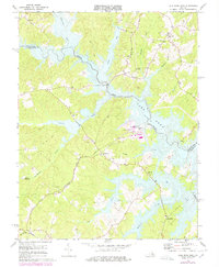
1973 Map of Lake Anna West
USGS Topo · Published 1978About this map
The North Anna River valley in the early 1970s is a landscape in transition, dominated by the newly formed Lake Anna and the looming North Anna Nuclear Powerplant. This survey captures the rural infrastructure of Louisa Co and Spotsylvania Co just as the reservoir altered the local topography. While the northern waters submerge old stream beds like Pigeon Run and Pamunkey Creek, the surrounding hills remain dotted with traditional landmarks. Family and community history is anchored by numerous small churches and cemeteries, including Edgewood Ch and Elk Creek Ch. Industrial remnants such as Whitlock Millpond and the Chesapeake and Ohio railroad line trace the older economic patterns of the region, contrasting with the modern substation and radio towers near the river's bend.
Find a feature on this map
32 named features on this map. Tap any name to fly to it.
Don’t see what you’re looking for? This feature index may not catch every label — zoom into the map to look around manually.
Map Details
Editions of this 1973 Lake Anna West Map
3 editions found
Other maps of this area

1887 · Spottsylvania
USGS Topo · 1:125,000

1890 · Goochland
USGS Topo · 1:125,000

1892 · Spottsylvania
USGS Topo · 1:125,000

1892 · Goochland
USGS Topo · 1:125,000

1942 · Mineral
USGS Topo · 1:31,680

1942 · Lahore
USGS Topo · 1:31,680

1942 · Partlow
USGS Topo · 1:31,680

1942 · Belmont
USGS Topo · 1:31,680

1942 · Contrary Creek
USGS Topo · 1:31,680

1942 · Brokenburg
USGS Topo · 1:31,680