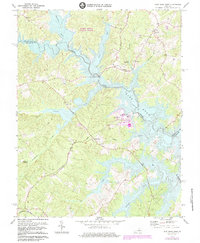
1973 Map of Lake Anna West
USGS Topo · Published 1984About this map
Lake Anna State Park and the sprawling waters of North Anna Lake dominate this landscape along the border of Spotsylvania and Louisa Counties. At the time of this early 1970s revision, the industrial footprint of the North Anna Nuclear Powerplant appears prominently on the shoreline, marking a significant era of infrastructure development for the region. The map captures the flooded valleys where Pigeon Run and Sturgeon Creek meet the reservoir, altering the historical terrain of the North Anna River.
Find a feature on this map
29 named features on this map. Tap any name to fly to it.
Don’t see what you’re looking for? This feature index may not catch every label — zoom into the map to look around manually.
Map Details
Editions of this 1973 Lake Anna West Map
3 editions found
Other maps of this area

1887 · Spottsylvania
USGS Topo · 1:125,000

1890 · Goochland
USGS Topo · 1:125,000

1892 · Spottsylvania
USGS Topo · 1:125,000

1892 · Goochland
USGS Topo · 1:125,000

1942 · Mineral
USGS Topo · 1:31,680

1942 · Lahore
USGS Topo · 1:31,680

1942 · Partlow
USGS Topo · 1:31,680

1942 · Belmont
USGS Topo · 1:31,680

1942 · Contrary Creek
USGS Topo · 1:31,680

1942 · Brokenburg
USGS Topo · 1:31,680