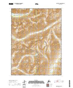
2018 Map of Lake Clark A-2 SW
USGS Topo · Published 2018About this map
The Lake and Peninsula Borough and Kenai Peninsula Borough meet along the dramatic ridgelines shown in this 2018 survey. This remote Alaskan landscape is primarily divided between the Lake Clark National Park and the Lake Clark National Preserve, protecting a wilderness dominated by steep glacial valleys and high mountain peaks. The drainage patterns are defined by the Tazimina River and Brooks Cr, which carve through the high-elevation terrain before moving toward the lower river basins. To the southeast, the Pile River provides another key drainage point. The map illustrates the preservation of these lands in their natural state, with the borough boundary lines following the natural crests of the mountains, separating the interior lake systems from the coastal regions of the Kenai Peninsula.
Find a feature on this map
10 named features on this map. Tap any name to fly to it.
Don’t see what you’re looking for? This feature index may not catch every label — zoom into the map to look around manually.
Map Details
Editions of this 2018 Lake Clark A-2 SW Map
This is the sole edition of this map. No revisions or reprints were ever made.
Other maps of this area

1946 · Lake Clark
USGS Topo · 1:250,000

1951 · Lake Clark
USGS Topo · 1:250,000

1952 · Iliamna
USGS Topo · 1:250,000

1954 · Lake Clark A-3
USGS Topo · 1:63,360

1954 · Iliamna D-3
USGS Topo · 1:63,360

1957 · Iliamna
USGS Topo · 1:250,000

1958 · Iliamna D-2
USGS Topo · 1:63,360
1958 · Lake Clark A-2
USGS Topo · 1:63,360

1958 · Lake Clark
USGS Topo · 1:250,000
2018 · Iliamna D-2 NE
USGS Topo · 1:25,000