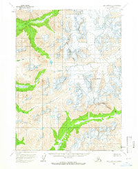
1958 Map of Lake Clark A-2
USGS Topo · Published 1966About this map
The Pile River drainage carves through the southern portion of this 1958 topographic study, where the high-altitude landscape is defined by extensive glacial formations and steep alpine basins. In the western reaches, the Gladiator Basin sits surrounded by unnamed peaks, feeding the northern flow of South Currant Creek. This map, based on 1957 photogrammetric methods, illustrates a period before significant modern infrastructure reached this part of the Kenai Peninsula Borough. The drainage patterns of Brooks Creek and the surrounding unmapped land lines reveal the raw topography of the Alaskan interior as it appeared mid-century, long before later developments would alter the character of these remote river valleys.
Find a feature on this map
6 named features on this map. Tap any name to fly to it.
Don’t see what you’re looking for? This feature index may not catch every label — zoom into the map to look around manually.
Map Details
Editions of this 1958 Lake Clark A-2 Map
2 editions found
Other maps of this area

1946 · Lake Clark
USGS Topo · 1:250,000

1951 · Lake Clark
USGS Topo · 1:250,000

1952 · Iliamna
USGS Topo · 1:250,000

1954 · Lake Clark A-3
USGS Topo · 1:63,360

1954 · Iliamna D-3
USGS Topo · 1:63,360

1954 · Lake Clark B-3
USGS Topo · 1:63,360

1957 · Iliamna
USGS Topo · 1:250,000

1958 · Iliamna D-2
USGS Topo · 1:63,360

1958 · Iliamna D-1
USGS Topo · 1:63,360

1958 · Lake Clark A-1
USGS Topo · 1:63,360