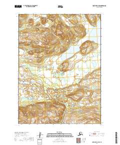
2019 Map of Lake Clark A-7 SW
USGS Topo · Published 2019About this map
Nikabuna Lakes dominate this interior Alaskan landscape within the Lake and Peninsula Borough. This 2019 survey documents a vast hydrographic network where the Nikabuna Lake basin feeds into the Chulitna River, illustrating the characteristic drainage patterns of the Lake Clark region. The topography is defined by significant elevation changes, with the land rising from the wetland-rich lake basins toward higher ground in the southern and northern sectors of the quadrangle. As a modern topographic study, it provides precise elevation contours and township boundaries including t1s r37w and t2s r36w, which are essential for understanding land management and natural resource boundaries in this unsettled portion of the Alaska Peninsula.
Find a feature on this map
7 named features on this map. Tap any name to fly to it.
Don’t see what you’re looking for? This feature index may not catch every label — zoom into the map to look around manually.
Map Details
Editions of this 2019 Lake Clark A-7 SW Map
This is the sole edition of this map. No revisions or reprints were ever made.
Other maps of this area

1946 · Lake Clark
USGS Topo · 1:250,000

1951 · Lake Clark
USGS Topo · 1:250,000

1952 · Iliamna
USGS Topo · 1:250,000

1954 · Lake Clark A-7
USGS Topo · 1:63,360

1954 · Lake Clark A-8
USGS Topo · 1:63,360

1954 · Iliamna D-8
USGS Topo · 1:63,360

1954 · Iliamna D-7
USGS Topo · 1:63,360

1957 · Iliamna
USGS Topo · 1:250,000

1958 · Lake Clark
USGS Topo · 1:250,000
2019 · Iliamna D-7 NW
USGS Topo · 1:25,000