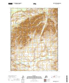
2019 Map of Lake Clark B-8 SW
USGS Topo · Published 2019About this map
Keefer Cr winds through the southern reaches of this interior Alaskan landscape, providing the primary drainage for a region characterized by dramatic elevation changes. The terrain is defined by several prominent upland masses, where contour lines tightly cluster to reveal steep slopes and ridges that dominate the northern and central sections of the quadrangle. Situated within the Lake and Peninsula Borough, the area is divided by the Public Land Survey System into townships t3n r39w, t3n r38w, t2n r39w, and t2n r38w. This map captures the wilderness state of the region in the early twenty-first century, showing no established roads or settlements, but rather a landscape shaped entirely by its natural hydrology and high-relief topography.
Find a feature on this map
6 named features on this map. Tap any name to fly to it.
Don’t see what you’re looking for? This feature index may not catch every label — zoom into the map to look around manually.
Map Details
Editions of this 2019 Lake Clark B-8 SW Map
This is the sole edition of this map. No revisions or reprints were ever made.
Other maps of this area

1946 · Lake Clark
USGS Topo · 1:250,000

1950 · Taylor Mountains
USGS Topo · 1:250,000

1951 · Lake Clark
USGS Topo · 1:250,000

1951 · Taylor Mountains
USGS Topo · 1:250,000

1954 · Lake Clark A-8
USGS Topo · 1:63,360

1954 · Taylor Mountains
USGS Topo · 1:250,000

1954 · Taylor Mountains B-1
USGS Topo · 1:63,360
1954 · Lake Clark B-8
USGS Topo · 1:63,360
1954 · Taylor Mountains A-1
USGS Topo · 1:63,360

1958 · Lake Clark
USGS Topo · 1:250,000