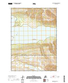
2018 Map of Lake Clark D-3 NE
USGS Topo · Published 2018About this map
Telaquana Lake dominates the central portion of this 2018 survey, its waters surrounded by the protected wilderness of the Lake Clark National Preserve. The landscape is defined by the transition between the Bethel Borough and the Lake and Peninsula Borough, a boundary line that cuts through the southern mountains. Significant water drainage is visible through the Trail Creek and its tributary, Trail Cr, which carve through the high-elevation terrain to the south. This area remains largely undeveloped, showcasing the natural drainage patterns and topographical character of the Alaskan interior before modern encroachment. The map illustrates a vast network of contours that detail the steep ascent from the lake shores into the surrounding peaks, providing a clear view of the hydrological relationship between the mountains and the lake basin.
Find a feature on this map
11 named features on this map. Tap any name to fly to it.
Don’t see what you’re looking for? This feature index may not catch every label — zoom into the map to look around manually.
Map Details
Editions of this 2018 Lake Clark D-3 NE Map
This is the sole edition of this map. No revisions or reprints were ever made.
Other maps of this area

1946 · Lake Clark
USGS Topo · 1:250,000

1951 · Lake Clark
USGS Topo · 1:250,000

1951 · Lime Hills
USGS Topo · 1:250,000

1954 · Lime Hills A-3
USGS Topo · 1:63,360

1954 · Lake Clark D-3
USGS Topo · 1:63,360

1958 · Lime Hills A-2
USGS Topo · 1:63,360
1958 · Lake Clark D-2
USGS Topo · 1:63,360

1958 · Lake Clark
USGS Topo · 1:250,000

1958 · Lime Hills
USGS Topo · 1:250,000
2018 · Lake Clark D-3 SE
USGS Topo · 1:25,000