
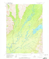
1954 Map of Lime Hills A-3
USGS Topo · Published 1965About this map
The Stony River meanders across this interior Alaska landscape, defining a wide glacial valley between high mountain ridges. This 1954 survey by the Army Map Service captures the region's wilderness character, where the river's braided channels and oxbows reflect a dynamic hydrologic environment. In the eastern portion of the quadrangle, the Two Lakes sit at the base of the mountains, with the Necons River flowing into the southern basin. Human activity is represented only by a single Cabin at the northern edge of the lake system, indicating the sparse seasonal occupation typical of the mid-20th century in this portion of the Seward Meridian. The map details complex drainage patterns and predetermined land lines from the Bureau of Land Management, documenting a transition from unsurveyed territory to a formally mapped wilderness.
Find a feature on this map
5 named features on this map. Tap any name to fly to it.
Don’t see what you’re looking for? This feature index may not catch every label — zoom into the map to look around manually.
Map Details
Editions of this 1954 Lime Hills A-3 Map
2 editions found
Other maps of this area

1946 · Lake Clark
USGS Topo · 1:250,000

1951 · Lake Clark
USGS Topo · 1:250,000

1951 · Lime Hills
USGS Topo · 1:250,000

1954 · Lime Hills B-4
USGS Topo · 1:63,360

1954 · Lake Clark D-3
USGS Topo · 1:63,360

1954 · Lime Hills A-4
USGS Topo · 1:63,360

1954 · Lime Hills B-3
USGS Topo · 1:63,360

1954 · Lake Clark D-4
USGS Topo · 1:63,360

1958 · Lime Hills A-2
USGS Topo · 1:63,360
1958 · Lake Clark D-2
USGS Topo · 1:63,360