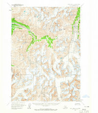
1958 Map of Lake Clark D-2
USGS Topo · Published 1965About this map
The glacial highlands of the Telaquana Pass dominate this late 1950s survey of the Alaska range, where the waters of Telaquana Lake feed into the Telaquana River. This is a landscape shaped by ice and elevation, notable for the high-altitude crevasses and the drainage systems of the Neacola River and Trail Creek. Mapped primarily through photogrammetric methods from 1957 aerial photography, the sheet records a wilderness essentially devoid of human infrastructure during this era, with no roads or trails yet established. The topography reflects a period when land lines represented unsurveyed locations predetermined by the Bureau of Land Management, emphasizing the territory's status as an emerging frontier before significant development.
Find a feature on this map
6 named features on this map. Tap any name to fly to it.
Don’t see what you’re looking for? This feature index may not catch every label — zoom into the map to look around manually.
Map Details
Editions of this 1958 Lake Clark D-2 Map
2 editions found
Other maps of this area

1946 · Lake Clark
USGS Topo · 1:250,000

1951 · Lake Clark
USGS Topo · 1:250,000

1951 · Lime Hills
USGS Topo · 1:250,000

1954 · Lake Clark C-3
USGS Topo · 1:63,360

1954 · Lime Hills A-3
USGS Topo · 1:63,360

1954 · Lake Clark D-3
USGS Topo · 1:63,360

1958 · Lime Hills A-2
USGS Topo · 1:63,360

1958 · Lake Clark C-2
USGS Topo · 1:63,360
1958 · Lime Hills A-1
USGS Topo · 1:63,360
1958 · Lake Clark D-1
USGS Topo · 1:63,360