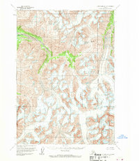
1958 Map of Lake Clark D-2
USGS Topo · Published 1970About this map
Telaquana Lake and its corresponding Telaquana River dominate this high-altitude landscape in the Lake Clark region. Published following late 1950s photogrammetric surveys, the map documents a transition from the drainage basin toward the Kenai Peninsula Borough boundary. The terrain is marked by significant glaciological features, specifically multiple areas of crevasses that indicate active ice movement during this era. A natural corridor is formed by Telaquana Pass, providing a navigational route through the high peaks. The eastern portion of the quadrangle shows the headwaters of the Neacola River, while Trail Creek carves through the southwest. This document captures the wilderness state of the region before any road infrastructure or permanent settlements were established, reflecting the unsurveyed and unmarked land lines predetermined by the Bureau of Land Management.
Find a feature on this map
7 named features on this map. Tap any name to fly to it.
Don’t see what you’re looking for? This feature index may not catch every label — zoom into the map to look around manually.
Map Details
Editions of this 1958 Lake Clark D-2 Map
2 editions found
Other maps of this area

1946 · Lake Clark
USGS Topo · 1:250,000

1951 · Lake Clark
USGS Topo · 1:250,000

1951 · Lime Hills
USGS Topo · 1:250,000

1954 · Lake Clark C-3
USGS Topo · 1:63,360

1954 · Lime Hills A-3
USGS Topo · 1:63,360

1954 · Lake Clark D-3
USGS Topo · 1:63,360

1958 · Lime Hills A-2
USGS Topo · 1:63,360
1958 · Lake Clark D-2
USGS Topo · 1:63,360

1958 · Lake Clark C-2
USGS Topo · 1:63,360
1958 · Lime Hills A-1
USGS Topo · 1:63,360