
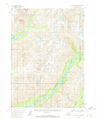
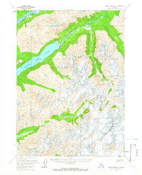
1958 Map of Lake Clark C-2
USGS Topo · Published 1965About this map
The Tlikakila River carves a massive glacial valley through this high-altitude landscape in the late 1950s. This survey, based on 1957 aerial photography, reveals a wilderness defined by profound vertical relief and dramatic watercourses before the formal establishment of modern park boundaries. To the west, the Twin Lakes sit within deep basins, while the Kijik River and Chokotonk River drain the surrounding mountain masses. The map serves as a vital record of the Seward Meridian's unsurveyed interior, showing land lines predetermined by the Bureau of Land Management that had not yet been marked on the ground at the time of the 1958 field annotation. It captures a moment of pure topographical study in a region where no roads or trails were yet documented, focusing entirely on the natural drainage systems and ice-sculpted peaks.
Find a feature on this map
4 named features on this map. Tap any name to fly to it.
Don’t see what you’re looking for? This feature index may not catch every label — zoom into the map to look around manually.
Map Details
Editions of this 1958 Lake Clark C-2 Map
2 editions found
Other maps of this area

1946 · Lake Clark
USGS Topo · 1:250,000

1951 · Lake Clark
USGS Topo · 1:250,000

1954 · Lake Clark C-3
USGS Topo · 1:63,360

1954 · Lake Clark D-3
USGS Topo · 1:63,360

1954 · Lake Clark B-3
USGS Topo · 1:63,360

1958 · Lake Clark B-1
USGS Topo · 1:63,360
1958 · Lake Clark D-2
USGS Topo · 1:63,360
1958 · Lake Clark D-1
USGS Topo · 1:63,360
1958 · Lake Clark C-1
USGS Topo · 1:63,360
1958 · Lake Clark B-2
USGS Topo · 1:63,360