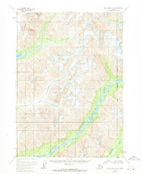
1958 Map of Lake Clark C-2
USGS Topo · Published 1971About this map
The Tlikakila River valley forms a central corridor through this remote Alaskan terrain, where high peaks and glacial valleys define the interior of what is now the Lake and Peninsula Borough. During the late 1950s, when these photogrammetric records were first compiled, the landscape remained largely untouched by permanent roads or settlements. In the northwest, the map captures a portion of the Twin Lakes system, while the Kijik River and Chokotonk River drain the surrounding mountain ranges toward the south. The eastern edge of the quadrangle marks the boundary transition toward the Kenai Peninsula, illustrating a period when this vast wilderness was documented primarily through aerial survey methods before the establishment of modern infrastructure.
Find a feature on this map
6 named features on this map. Tap any name to fly to it.
Don’t see what you’re looking for? This feature index may not catch every label — zoom into the map to look around manually.
Map Details
Editions of this 1958 Lake Clark C-2 Map
2 editions found
Other maps of this area

1946 · Lake Clark
USGS Topo · 1:250,000

1951 · Lake Clark
USGS Topo · 1:250,000

1954 · Lake Clark C-3
USGS Topo · 1:63,360

1954 · Lake Clark D-3
USGS Topo · 1:63,360

1954 · Lake Clark B-3
USGS Topo · 1:63,360

1958 · Lake Clark B-1
USGS Topo · 1:63,360
1958 · Lake Clark D-2
USGS Topo · 1:63,360

1958 · Lake Clark C-2
USGS Topo · 1:63,360
1958 · Lake Clark D-1
USGS Topo · 1:63,360
1958 · Lake Clark C-1
USGS Topo · 1:63,360