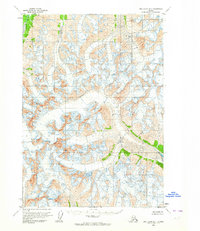
1958 Map of Lake Clark D-1
USGS Topo · Published 1965About this map
The Neacola River headwaters and high-altitude glacial systems define this remote Alaskan interior landscape as it was documented in the late 1950s. Located in the Lake Clark region, the map reveals a wilderness of ice and moving water, with the Glacier Fork Tlikakila R cutting through the southeast. This survey was created using photogrammetric methods from 1957 aerial photography and field annotated in 1958, capturing the precise state of the ice fields before several decades of modern glacial recession. The topography is dominated by extensive Crevasses, marking the active flow of glaciers that feed into the regional river systems. This is a map of pure geography, showing a land without established roads or trails, where the only named features are the primary waterways and the dangerous fractures in the ice.
Find a feature on this map
3 named features on this map. Tap any name to fly to it.
Don’t see what you’re looking for? This feature index may not catch every label — zoom into the map to look around manually.
Map Details
Editions of this 1958 Lake Clark D-1 Map
2 editions found
Other maps of this area

1944 · Kenai
USGS Topo · 1:250,000

1946 · Lake Clark
USGS Topo · 1:250,000

1949 · Tyonek
USGS Topo · 1:250,000

1950 · Kenai
USGS Topo · 1:250,000

1951 · Lake Clark
USGS Topo · 1:250,000

1951 · Tyonek
USGS Topo · 1:250,000

1951 · Lime Hills
USGS Topo · 1:250,000

1958 · Kenai D-8
USGS Topo · 1:63,360

1958 · Kenai C-8
USGS Topo · 1:63,360

1958 · Tyonek
USGS Topo · 1:250,000