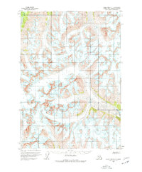
1958 Map of Lake Clark D-1
USGS Topo · Published 1977About this map
The Neacola River and the Glacier Fk Tlikakila R define the hydrological character of this high-altitude landscape in the Kenai Peninsula Borough. Surveyed in the late 1950s using photogrammetric methods from 1957 aerial photography, the topography reveals a dynamic environment dominated by ice and moving water. The map provides a specialized look at the glacial geography of the era, specifically calling out numerous Crevasses across the high ice fields. While the region lacks settlements or human infrastructure, the detailed contouring by the Geological Survey illustrates the steep drainage basins and the precise path of the rivers as they emerge from the surrounding glacial systems.
Find a feature on this map
5 named features on this map. Tap any name to fly to it.
Don’t see what you’re looking for? This feature index may not catch every label — zoom into the map to look around manually.
Map Details
Editions of this 1958 Lake Clark D-1 Map
2 editions found
Other maps of this area

1944 · Kenai
USGS Topo · 1:250,000

1946 · Lake Clark
USGS Topo · 1:250,000

1949 · Tyonek
USGS Topo · 1:250,000

1950 · Kenai
USGS Topo · 1:250,000

1951 · Lake Clark
USGS Topo · 1:250,000

1951 · Tyonek
USGS Topo · 1:250,000

1951 · Lime Hills
USGS Topo · 1:250,000

1958 · Kenai D-8
USGS Topo · 1:63,360

1958 · Kenai C-8
USGS Topo · 1:63,360

1958 · Tyonek
USGS Topo · 1:250,000