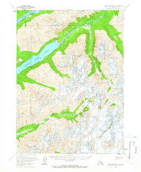
1958 Map of Lake Clark B-2
USGS Topo · Published 1966About this map
Little Lake Clark dominates the northwestern landscape of this mid-century survey, serving as a focal point for the complex glacial and fluvial systems of the region. The map documents a wilderness environment defined by the confluence of the Tlikakila River and the Chokotonk River, which carve deep valleys through the high terrain. The southern portion of the quadrangle is marked by the drainage of Currant Creek and South Currant Creek, revealing the intricate hydrological patterns of the Kenai Peninsula Borough boundary. Based on 1957 aerial photography, the sheet captures the state of this unsurveyed territory just as the Bureau of Land Management was establishing predetermined land lines. The absence of roads or trails highlights the isolation of this terrain during the late 1950s, providing a baseline for researchers studying the evolution of Alaskas protected wilderness areas.
Find a feature on this map
7 named features on this map. Tap any name to fly to it.
Don’t see what you’re looking for? This feature index may not catch every label — zoom into the map to look around manually.
Map Details
Editions of this 1958 Lake Clark B-2 Map
2 editions found
Other maps of this area

1946 · Lake Clark
USGS Topo · 1:250,000

1951 · Lake Clark
USGS Topo · 1:250,000

1954 · Lake Clark C-3
USGS Topo · 1:63,360

1954 · Lake Clark A-3
USGS Topo · 1:63,360

1954 · Lake Clark B-3
USGS Topo · 1:63,360

1958 · Lake Clark A-1
USGS Topo · 1:63,360

1958 · Lake Clark B-1
USGS Topo · 1:63,360

1958 · Lake Clark C-2
USGS Topo · 1:63,360
1958 · Lake Clark C-1
USGS Topo · 1:63,360
1958 · Lake Clark A-2
USGS Topo · 1:63,360