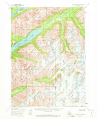
1958 Map of Lake Clark B-2
USGS Topo · Published 1972About this map
Lake Clark and its smaller counterpart, Little Lake Clark, dominate the western half of this interior Alaskan landscape. This 1958 survey captures a purely natural environment where the Chigmit Mountains meet a network of glacial waterways. The drainage patterns are clearly defined by the Tlikakila River in the northwest and the Chokotonk River cutting through the center of the quadrangle. High-altitude details are noted in the southeastern corner, where Crevasses are marked among the mountain peaks, indicating active glacial features. The map also delineates the jurisdictional boundary for the Kenai Peninsula Borough. With no roads or trails indicated, the map focuses on the raw topography of the lake basins and the steep drainages of Currant Creek and South Currant Creek.
Find a feature on this map
9 named features on this map. Tap any name to fly to it.
Don’t see what you’re looking for? This feature index may not catch every label — zoom into the map to look around manually.
Map Details
Editions of this 1958 Lake Clark B-2 Map
2 editions found
Other maps of this area

1946 · Lake Clark
USGS Topo · 1:250,000

1951 · Lake Clark
USGS Topo · 1:250,000

1954 · Lake Clark C-3
USGS Topo · 1:63,360

1954 · Lake Clark A-3
USGS Topo · 1:63,360

1954 · Lake Clark B-3
USGS Topo · 1:63,360

1958 · Lake Clark A-1
USGS Topo · 1:63,360

1958 · Lake Clark B-1
USGS Topo · 1:63,360

1958 · Lake Clark C-2
USGS Topo · 1:63,360
1958 · Lake Clark C-1
USGS Topo · 1:63,360
1958 · Lake Clark A-2
USGS Topo · 1:63,360