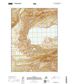
2019 Map of Lake Clark D-6 NE
USGS Topo · Published 2019About this map
Whitefish Lake dominates this terrain, surrounded by a dense network of wetlands and smaller ponds that characterize the northern reaches of the Lake and Peninsula Borough. The Hoholitna River winds through the southwestern corner of the sheet, providing a primary drainage route through this uninhabited landscape. A significant political boundary bisects the southern portion of the map, marking the line between the borough and the Bethel Census Area. This topographic study reveals a landscape shaped by glacial activity and water, where the intricate hydrography of the Whitefish Lake basin meets the foothills and rising contours to the south and east.
Find a feature on this map
3 named features on this map. Tap any name to fly to it.
Don’t see what you’re looking for? This feature index may not catch every label — zoom into the map to look around manually.
Map Details
Editions of this 2019 Lake Clark D-6 NE Map
This is the sole edition of this map. No revisions or reprints were ever made.
Other maps of this area

1946 · Lake Clark
USGS Topo · 1:250,000

1951 · Lake Clark
USGS Topo · 1:250,000

1951 · Lime Hills
USGS Topo · 1:250,000

1954 · Lime Hills A-5
USGS Topo · 1:63,360

1954 · Lake Clark D-5
USGS Topo · 1:63,360

1954 · Lime Hills A-6
USGS Topo · 1:63,360
1954 · Lake Clark D-6
USGS Topo · 1:63,360

1958 · Lake Clark
USGS Topo · 1:250,000

1958 · Lime Hills
USGS Topo · 1:250,000
2018 · Lake Clark D-5 SW
USGS Topo · 1:25,000