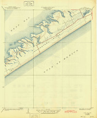
1933 Map of Lake Como
USGS Topo · Published 1945About this map
Galveston Island stretches along the Texas coast in this early 1930s survey, revealing a landscape defined by the shifting interface of land and water. The small settlement of Dana serves as a lone hub of activity on this section of the barrier island, situated near the marshy edges of Lake Como. The map depicts a relatively undeveloped era for this portion of the coastline, where the infrastructure is limited to a primary road and a handful of surveyed plots.
Find a feature on this map
7 named features on this map. Tap any name to fly to it.
Don’t see what you’re looking for? This feature index may not catch every label — zoom into the map to look around manually.
Map Details
Editions of this 1933 Lake Como Map
This is the sole edition of this map. No revisions or reprints were ever made.
Other maps of this area

1929 · Karankawa Lake
USGS Topo · 1:24,000

1929 · Hitchcock
USGS Topo · 1:24,000

1929 · Virginia Point
USGS Topo · 1:24,000

1930 · Galveston
USGS Topo · 1:24,000

1931 · Lake Como
USGS Topo · 1:24,000

1932 · Hitchcock
USGS Topo · 1:31,680

1932 · Virginia Point
USGS Topo · 1:31,680

1933 · Karankawa Lake
USGS Topo · 1:31,680

1933 · San Luis Pass
USGS Topo · 1:31,680
1933 · Galveston
USGS Topo · 1:31,680