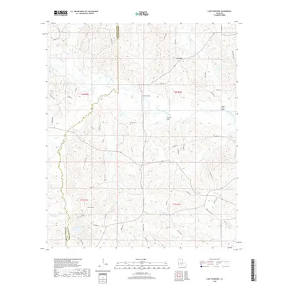
2018 Map of Lake Foursome
USGS Topo · Published 2018About this map
Corinth sits near the northern boundary of this Lincoln Parish landscape, where the terrain is defined by the winding course of Bayou D'Arbonne and its many tributaries. The area's water network is exceptionally dense, featuring named points like Alligator Hole and the sharp turn at Petty Lake Bend. To the southwest, Lake Foursome serves as a prominent landmark along the parish line. The map reveals a rural economy integrated with the natural landscape, indicated by the presence of Oil Well Rd and various logging routes. Local history is etched into the road names, from the legacy of education found along Nobles School Rd to the traditional transit points like Mays Crossing Rd and Brazells Bridge. This 2018 survey provides a precise view of the interface between Claiborne and Lincoln Parishes, showcasing a region where many small streams like Bullock Cr and Sugar Creek converge.
Find a feature on this map
60 named features on this map. Tap any name to fly to it.
Don’t see what you’re looking for? This feature index may not catch every label — zoom into the map to look around manually.
Map Details
Editions of this 2018 Lake Foursome Map
This is the sole edition of this map. No revisions or reprints were ever made.
Other maps of this area

1950 · Ruston
USGS Topo · 1:62,500

1950 · Arcadia
USGS Topo · 1:62,500

1951 · Arcadia
USGS Topo · 1:62,500

1951 · Ruston
USGS Topo · 1:62,500

1951 · Summerfield
USGS Topo · 1:62,500

1951 · Bernice
USGS Topo · 1:62,500

1955 · Shreveport
USGS Topo · 1:250,000

1956 · Shreveport
USGS Topo · 1:250,000

1984 · Shreveport
USGS Topo · 1:250,000

1985 · Monroe North
USGS Topo · 1:100,000