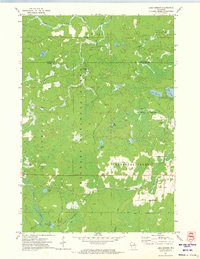
1972 Map of Lake Gordon
USGS Topo · Published 1974About this map
Nicolet National Forest dominates this northern Wisconsin landscape, characterized by a dense network of glacial lakes and river headwaters in the early 1970s. The map illustrates the industrial and recreational infrastructure of the era, including the Soo Line railroad cutting across the southern terrain near the small settlement of Bonneval. High points are marked by the Newald Lookout Tower along Newald Tower Road, a critical piece of forest management infrastructure.
Find a feature on this map
29 named features on this map. Tap any name to fly to it.
Don’t see what you’re looking for? This feature index may not catch every label — zoom into the map to look around manually.
Map Details
Editions of this 1972 Lake Gordon Map
2 editions found
Other maps of this area

1939 · Goodman
USGS Topo · 1:48,000

1939 · Laona
USGS Topo · 1:48,000

1939 · Long Lake
USGS Topo · 1:48,000

1941 · Florence
USGS Topo · 1:48,000

1946 · Laona
USGS Topo · 1:48,000

1946 · Goodman
USGS Topo · 1:48,000

1948 · Long Lake
USGS Topo · 1:48,000

1954 · Iron Mountain
USGS Topo · 1:250,000

1959 · Iron Mountain
USGS Topo · 1:250,000
1962 · Florence SW
USGS Topo · 1:24,000