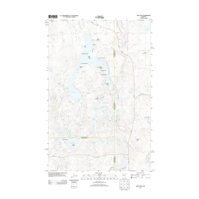
2013 Map of Lake Itasca
USGS Topo · Published 2013About this map
Lake Itasca serves as the focal point of this northern Minnesota landscape, marking the celebrated headwaters where the Mississippi River begins its long journey south. Within the protected boundaries of Itasca State Park, the map details a dense network of water bodies and glacial features, including Elk Lake, Mary Lake, and the distinctive Schoolcraft Island. For those tracing local history or genealogy, the presence of the Pioneer Cem and Alice Cem provides specific points of interest. The area's conservation and recreation infrastructure is well-established, featuring the Alton Heights Lookout Tower and multiple lakeside sites like Pine Ridge Campground and Bear Paw Campground. Small creeks such as Nicolet Cr and Boutwell Cr feed into the larger basins, illustrating the complex hydrology of this high-latitude drainage divide.
Find a feature on this map
86 named features on this map. Tap any name to fly to it.
Don’t see what you’re looking for? This feature index may not catch every label — zoom into the map to look around manually.
Map Details
Editions of this 2013 Lake Itasca Map
This is the sole edition of this map. No revisions or reprints were ever made.
Other maps of this area

1954 · Bemidji
USGS Topo · 1:250,000

1957 · Bemidji
USGS Topo · 1:250,000

1958 · Bemidji
USGS Topo · 1:250,000

1969 · Anchor Hill
USGS Topo · 1:24,000

1969 · Big Basswood Lake
USGS Topo · 1:24,000

1969 · Heart Lake
USGS Topo · 1:24,000

1972 · La Salle Lake
USGS Topo · 1:24,000
1972 · Two Inlets
USGS Topo · 1:24,000
1972 · Lake Itasca
USGS Topo · 1:24,000
1972 · Lake Hattie
USGS Topo · 1:24,000