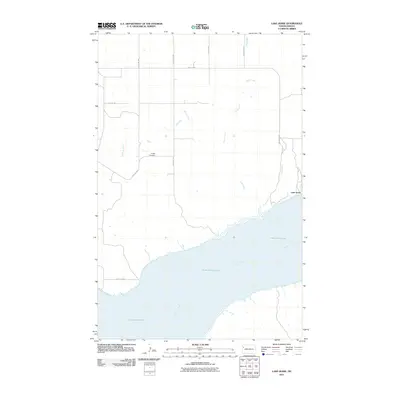
2011 Map of Lake Jessie
USGS Topo · Published 2011About this map
Lake Sakakawea dominates the southern landscape of this Williams County quadrant, where the waters of the dammed Missouri River expand across the valley floor. The map illustrates a transitional prairie environment where several intermittent drainage systems, including Willow Creek, Cedar Creek, and Plum Creek, move southward toward the reservoir. In the northeast, the small settlement of Lake Jessie sits near its namesake water body, reflecting the sparse, road-oriented development typical of the North Dakota plains. Evidence of early community life is preserved at Hauge Cemetery, a lonely landmark positioned along the section lines. The grid of rural routes, such as 128th Ave NW and County Hwy-11, provides the primary structure for this agricultural region, connecting isolated homesteads to the river system and local trade centers.
Find a feature on this map
16 named features on this map. Tap any name to fly to it.
Don’t see what you’re looking for? This feature index may not catch every label — zoom into the map to look around manually.
Map Details
Editions of this 2011 Lake Jessie Map
This is the sole edition of this map. No revisions or reprints were ever made.
Other maps of this area

1911 · Ray
USGS Topo · 1:125,000

1953 · Williston
USGS Topo · 1:250,000

1953 · Watford City
USGS Topo · 1:250,000

1957 · Williston
USGS Topo · 1:250,000

1957 · Watford City
USGS Topo · 1:250,000

1959 · Williston East
USGS Topo · 1:24,000

1967 · Watford City
USGS Topo · 1:250,000

1978 · Lake Jessie
USGS Topo · 1:24,000

1978 · Watford City NW
USGS Topo · 1:24,000
1978 · Camp Creek East
USGS Topo · 1:24,000