
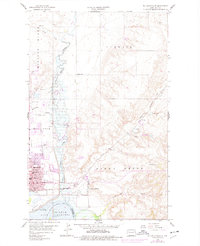
1959 Map of Williston East
USGS Topo · Published 1960About this map
The confluence of the Little Muddy River and the Missouri River anchors this 1959 survey of the eastern environs of Williston. The landscape is transitioning from a river-and-rail hub to a modern mid-century city, with the Northern railroad line and a series of gravel pits supporting local industry. In the southern reach of the map, the Garrison Lake backwaters appear just below the Williston city limits, with a specific note regarding the spillway elevation 1825 marking the impact of the newly formed reservoir on the Missouri basin.
Find a feature on this map
37 named features on this map. Tap any name to fly to it.
Don’t see what you’re looking for? This feature index may not catch every label — zoom into the map to look around manually.
Map Details
Editions of this 1959 Williston East Map
2 editions found
Other maps of this area

1911 · Ray
USGS Topo · 1:125,000

1953 · Williston
USGS Topo · 1:250,000

1957 · Williston
USGS Topo · 1:250,000

1959 · Marmon SE
USGS Topo · 1:24,000

1959 · Williston West
USGS Topo · 1:24,000

1974 · Otter Tail Creek
USGS Topo · 1:24,000

1978 · Lake Jessie
USGS Topo · 1:24,000

1978 · Spring Brook
USGS Topo · 1:24,000
1979 · Stockyard Creek
USGS Topo · 1:24,000
1979 · Williston SE
USGS Topo · 1:24,000