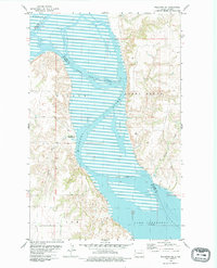
1979 Map of Williston SE
USGS Topo · Published 1979About this map
The Missouri River corridor in McKenzie County is captured here at a moment of transition, showing the controlled inundation areas surrounding the northern reaches of Lake Sakakawea. The landscape is defined by the sharp contrast between the broad river bottomlands and the dissected uplands of Wilbur, Stony Creek, and Poe. An indefinite boundary marks the shifting path of the river, which serves as the dividing line between Williams and McKenzie counties. Significant for its recreational and environmental detail, the sheet identifies the Indian Creek Bay Recreation Area along the western shore. The map also traces the winding courses of Indian Creek and Willow Creek as they approach the Missouri, providing essential data on the local drainage patterns and topography prior to further shifts in the reservoir's levels.
Find a feature on this map
11 named features on this map. Tap any name to fly to it.
Don’t see what you’re looking for? This feature index may not catch every label — zoom into the map to look around manually.
Map Details
Editions of this 1979 Williston SE Map
This is the sole edition of this map. No revisions or reprints were ever made.
Other maps of this area

1911 · Ray
USGS Topo · 1:125,000

1953 · Williston
USGS Topo · 1:250,000

1953 · Watford City
USGS Topo · 1:250,000

1957 · Williston
USGS Topo · 1:250,000

1957 · Watford City
USGS Topo · 1:250,000

1959 · Williston West
USGS Topo · 1:24,000

1959 · Williston East
USGS Topo · 1:24,000

1967 · Watford City
USGS Topo · 1:250,000

1978 · Lake Jessie
USGS Topo · 1:24,000

1978 · Watford City NW
USGS Topo · 1:24,000