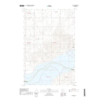
2017 Map of Lake Jessie
USGS Topo · Published 2017About this map
Lake Sakakawea and the winding course of the Missouri River dominate this modern topographical record along the Williams and McKenzie County line. The landscape is defined by the dramatic relief of river breaks and coulees, where drainage systems like Plum Creek, Willow Creek, and Cedar Creek carve through the North Dakota badlands. This specific era of mapping shows the high-water extent of the reservoir, illustrating the massive scale of the water system compared to the more intimate local landmarks like the Hauge Cemetery. Human activity is primarily traced through the grid of rural routes such as County Highway 11 A and 130 Road NW, which navigate the high plateaus above the river valley. The map provides a precise account of the shoreline and elevation changes in a region where the geography is constantly reshaped by the Missouri and its tributaries.
Find a feature on this map
18 named features on this map. Tap any name to fly to it.
Don’t see what you’re looking for? This feature index may not catch every label — zoom into the map to look around manually.
Map Details
Editions of this 2017 Lake Jessie Map
This is the sole edition of this map. No revisions or reprints were ever made.
Other maps of this area

1911 · Ray
USGS Topo · 1:125,000

1953 · Williston
USGS Topo · 1:250,000

1953 · Watford City
USGS Topo · 1:250,000

1957 · Williston
USGS Topo · 1:250,000

1957 · Watford City
USGS Topo · 1:250,000

1959 · Williston East
USGS Topo · 1:24,000

1967 · Watford City
USGS Topo · 1:250,000

1978 · Lake Jessie
USGS Topo · 1:24,000

1978 · Watford City NW
USGS Topo · 1:24,000
1978 · Camp Creek East
USGS Topo · 1:24,000