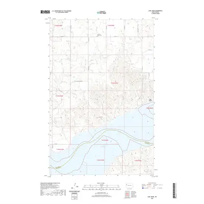
2020 Map of Lake Jessie
USGS Topo · Published 2020About this map
Lake Sakakawea dominates the southern landscape of this Williams County quadrangle, where the Missouri River valley was transformed into a massive reservoir. The terrain to the north is defined by a series of drainages, including Willow Cr, Cedar Cr, and Plum Cr, which carve through the prairie towards the lake's edge. This 2020 record of the land reveals the sparse, rural nature of the region, anchored by historical community markers such as Our Saviors Lutheran Cem and Hauge Cem. The map illustrates the intersection of several townships, including t153n r99w and t154n r99w, showing the enduring section-line road grid that organizes the North Dakota plains. Near the eastern edge, the small basin of Lake Jessie sits atop the higher ground, overlooking the complex system of coulees and ridges that lead down to the water's edge.
Find a feature on this map
19 named features on this map. Tap any name to fly to it.
Don’t see what you’re looking for? This feature index may not catch every label — zoom into the map to look around manually.
Map Details
Editions of this 2020 Lake Jessie Map
This is the sole edition of this map. No revisions or reprints were ever made.
Other maps of this area

1911 · Ray
USGS Topo · 1:125,000

1953 · Williston
USGS Topo · 1:250,000

1953 · Watford City
USGS Topo · 1:250,000

1957 · Williston
USGS Topo · 1:250,000

1957 · Watford City
USGS Topo · 1:250,000

1959 · Williston East
USGS Topo · 1:24,000

1967 · Watford City
USGS Topo · 1:250,000

1978 · Lake Jessie
USGS Topo · 1:24,000

1978 · Watford City NW
USGS Topo · 1:24,000
1978 · Camp Creek East
USGS Topo · 1:24,000