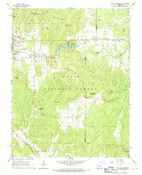
1968 Map of Lake Killarney
USGS Topo · Published 1970About this map
The neighboring towns of Ironton and Arcadia anchor the northwestern corner of this study, positioned near the foot of Pilot Knob where the local economy transitions from early mining to mid-century recreation. The landscape is defined by the heavy timber of the Clark National Forest, which surrounds numerous peaks including Grassy Mountain, Crane Mountain, and Turkey Foot Mountain. Central to the area's development is Lake Killarney, featuring the Killarney Shores settlement and the Arcadia Valley Bible Camp along its banks.
Find a feature on this map
53 named features on this map. Tap any name to fly to it.
Don’t see what you’re looking for? This feature index may not catch every label — zoom into the map to look around manually.
Map Details
Editions of this 1968 Lake Killarney Map
2 editions found
Other maps of this area

1926 · Des Arc
USGS Topo · 1:62,500

1929 · Des Arc
USGS Topo · 1:62,500

1930 · Coldwater
USGS Topo · 1:62,500

1937 · Ironton
USGS Topo · 1:48,000

1939 · Fredericktown
USGS Topo · 1:48,000

1945 · Ironton
USGS Topo · 1:62,500

1946 · Ironton
USGS Topo · 1:62,500

1947 · Fredericktown
USGS Topo · 1:62,500

1949 · Rolla
USGS Topo · 1:250,000

1949 · Coldwater
USGS Topo · 1:62,500