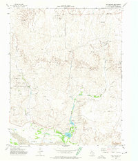
1972 Map of Lake Marvin
USGS Topo · Published 1974About this map
The Canadian River floodplains and the high Texas Panhandle plains meet in this survey of Hemphill County. The landscape is defined by the hydrologic network of Persimmon Creek and Boggy Creek, which feed into local water bodies such as Lake Marvin and Lake Kiowa. The presence of a Campground and the Gene Howe Wildlife Management Area indicates a region utilized for conservation and recreation during the early 1970s.
Find a feature on this map
20 named features on this map. Tap any name to fly to it.
Don’t see what you’re looking for? This feature index may not catch every label — zoom into the map to look around manually.
Map Details
Editions of this 1972 Lake Marvin Map
This is the sole edition of this map. No revisions or reprints were ever made.
Other maps of this area

1954 · Perryton
USGS Topo · 1:250,000

1954 · Amarillo
USGS Topo · 1:250,000

1958 · Perryton
USGS Topo · 1:250,000

1958 · Amarillo
USGS Topo · 1:250,000

1967 · Gem
USGS Topo · 1:24,000

1967 · Blue Ridge School
USGS Topo · 1:24,000

1967 · Canadian SE
USGS Topo · 1:24,000

1972 · Canadian East
USGS Topo · 1:24,000

1972 · Glazier
USGS Topo · 1:24,000
1972 · Dreyfoos
USGS Topo · 1:24,000