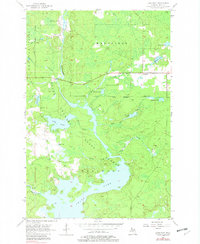
1956 Map of Lake Mary
USGS Topo · Published 1982About this map
The Michigamme River carves through this portion of the Copper Country, defining a landscape where industrial transit and massive water management projects intersect. By the mid-1950s, the extensive Peavy Pond and the Little Bull Diversion Canal show the significant modification of the waterway for regional power or utility needs. Settlement is concentrated around the historic mining nodes of Mansfield and Mansfield Location, while much of the surrounding territory is managed as the Mansfield State Forest and Mastodon State Forest.
Find a feature on this map
26 named features on this map. Tap any name to fly to it.
Don’t see what you’re looking for? This feature index may not catch every label — zoom into the map to look around manually.
Map Details
Editions of this 1956 Lake Mary Map
3 editions found
Other maps of this area

1899 · Sagola
USGS Topo · 1:62,500

1899 · Crystal Falls
USGS Topo · 1:62,500

1939 · Iron Mountain
USGS Topo · 1:48,000

1941 · Florence
USGS Topo · 1:48,000

1941 · Iron Mountain
USGS Topo · 1:48,000

1944 · Crystal Falls
USGS Topo · 1:24,000

1945 · Kelso Junction
USGS Topo · 1:24,000

1946 · Crystal Falls
USGS Topo · 1:31,680

1947 · Iron Mountain
USGS Topo · 1:48,000

1947 · Stager
USGS Topo · 1:24,000